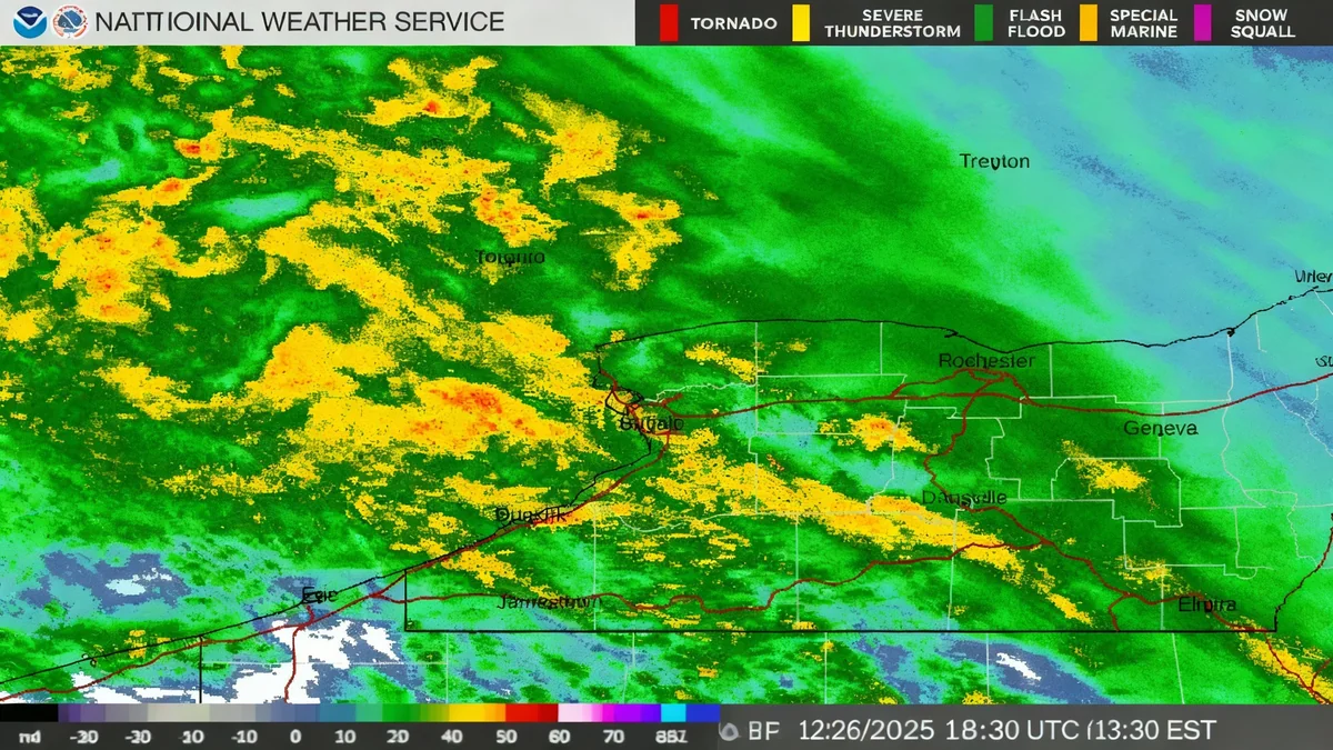


Western New York is experiencing a significant wintry mix of sleet, freezing rain, and snow today. This weather system is slowing down post-Christmas travel across the Buffalo-Niagara region and surrounding areas. A Winter Weather Advisory remains in effect for all of Western New York through early Saturday morning, urging residents to exercise caution.
Key Takeaways
- A wintry mix of sleet, freezing rain, and snow is affecting Western New York.
- Travel conditions are expected to worsen throughout Friday.
- Ice accumulations could reach up to 0.50 inches in parts of Chautauqua County.
- Snowfall is predicted between 1 to 4 inches for the Buffalo-Niagara area.
- The system should clear by late Friday evening, with a quieter Saturday ahead.
Current Weather Conditions and Forecast
The region is currently under a Winter Weather Advisory. This advisory covers all of Western New York. Forecasters at the National Weather Service predict varying precipitation types across the area. The further south one travels, the more dominant ice and sleet will be. Conversely, northern areas will see more snow.
For those in between, a complex mix of all three precipitation types is expected. This includes areas like Buffalo and Niagara Falls. Temperatures are below freezing across the entire region today. This means any precipitation falling will freeze upon contact with surfaces, making roads and sidewalks hazardous.
"Travel conditions across the entire region are going to deteriorate throughout the day," stated National Weather Service meteorologist Phillip Pandolfo.
This warning highlights the need for careful driving and avoiding unnecessary travel if possible. The mixed precipitation will create slick surfaces, increasing the risk of accidents.
Regional Impact
- Buffalo-Niagara: Expected snow accumulations of 1 to 4 inches, with sleet limiting higher totals.
- Western Southern Tier: Ice and sleet will be the primary concerns.
- Chautauqua County: Potential for 0.25 to 0.50 inches of ice accumulation.
Ice Accumulation and Snowfall Expectations
The National Weather Service is closely monitoring ice accumulations, especially in the western southern tier. This area could see 0.10 to 0.25 inches of ice. Parts of Chautauqua County face a higher risk, with potential for 0.25 to 0.50 inches of freezing rain. There is a slight chance Chautauqua County could even exceed 0.50 inches, which would trigger an Ice Storm Warning.
Snowfall amounts for the Buffalo-Niagara region are less certain due to the mixed precipitation. Current projections suggest 1 to 4 inches of snow. However, if the precipitation remains primarily snow, accumulations could rise to 3 to 6 inches.
Meteorologist Andy Parker noted the geographical variation. "The further south you go, the icier it's going to be, the further north you are, the snowier it's going to be." This highlights the diverse conditions residents will encounter depending on their location within Western New York.
Travel Advisory and Safety Measures
Authorities advise against non-essential travel during the advisory period. If travel is unavoidable, drivers should reduce speeds, maintain extra distance between vehicles, and be aware of black ice. Pedestrians should also be cautious on icy sidewalks.
Understanding Winter Weather Advisories
A Winter Weather Advisory is issued when hazardous winter weather conditions are expected. These conditions can cause significant inconveniences and may be life-threatening if precautions are not taken. It is less severe than a Winter Storm Warning or an Ice Storm Warning, but still indicates dangerous conditions.
Looking Ahead: Weekend Forecast
The wintry mix is expected to taper off from west to east Friday night. Most of the precipitation should conclude by late evening across Western New York. This brings relief for Saturday.
"Tomorrow, this system is gone, it's a quiet day across Western New York," Parker confirmed. This means Saturday will offer a reprieve from the hazardous conditions, allowing for safer travel and outdoor activities.
However, the calm will be short-lived. Sunday brings a significant change in weather patterns. A substantial warm-up is forecast, accompanied by widespread rain across much of the area. Southwest winds will also pick up later in the day.
"We’re expecting a pretty big warmup," Pandolfo commented on the Sunday forecast.
This warmer, wetter weather will affect the Buffalo Bills game against the Philadelphia Eagles at Highmark Stadium on Sunday. No stadium dig-out will be needed. However, fans should prepare for rain and strong winds.
Upcoming Weather Snapshot
- Friday Night: Precipitation tapers off.
- Saturday: Quiet day, clearing skies.
- Sunday: Significant warm-up, widespread rain, increasing southwest winds.
- Monday-Wednesday: Colder air returns, bringing lake effect snow.
Beyond the Weekend: Return of Colder Air
The mild, rainy conditions on Sunday will not last. Colder air is expected to return to the region late Monday. This will bring with it the possibility of lake effect snow. These conditions are forecast to persist through Wednesday.
Residents should stay informed about changing weather patterns. Local weather updates will provide the most current information. Preparing for varied winter conditions remains essential throughout the season.
The dynamic weather in Western New York shows the importance of staying prepared. From icy roads to heavy rain, each day presents new challenges for travelers and residents alike.